


Green Marble, Reek Mountain, and the Passage of Time
More vintage postcards--as well as a few notes--on Irish tradition and the increasingly vanishing art of travelling in both style and with attention to history

Time flies, when you’re having a good time—and in this third posting, off we go to the Western reaches of the Emerald Isle.
As I mentioned in my very first instalment about Ireland, this is the area that I’ve never been to, but I can clearly see what I’ve been missing out on.


And now, without much further ado, more postcards from the 1970s in Ireland.
Behold the Cliffs of Moher
We’re moving northwards along the west coast of Ireland, and one of the main features of these reaches are the rugged coastal features, carved into the Emerald Island by millennia of Atlantic storms.
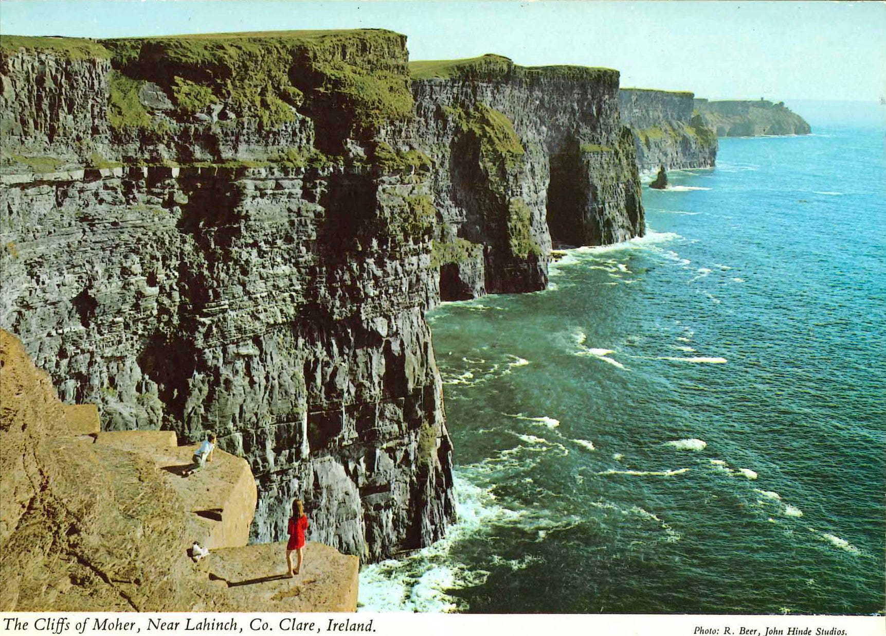
Five miles north-west of Lahinch, these are one of the outstanding coastal features of County Clare. This great “Wall of Thomond”, consisting of horizontal beds of millstone, grit and sandstone stretches nearly for five miles from Hag’s Head (450 ft.) to O’Brien’s Tower, where they attain a height of 700 ft. Near O’Brien’s Tower, there is a car park, and viewing-platform for visitors. O’Brien’s Tower, a circular castle style structure was erected in 1853 by Cornelius O’Brien.
Since that 19th-century tower isn’t visible on the postcard, click here if you’re interested (Wikipedia).
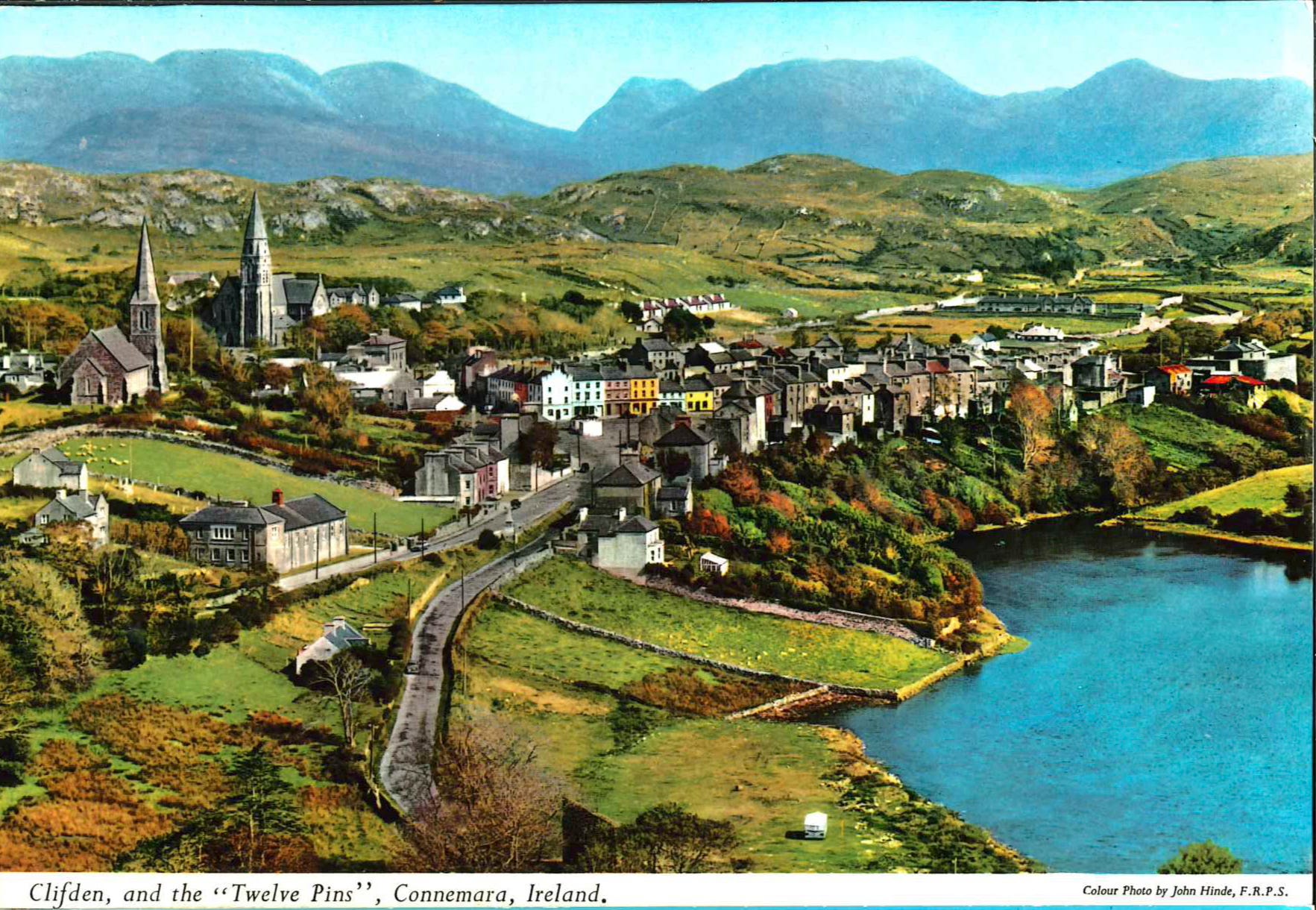
Clifden is the “capital” of Connemara, the region of wild and rugged grandeur dominated by the rocky mountain range of the Twelve Bens which rise from a coastline fretted and carved into hundreds of rocky inlets. Connemara has inspired many famous paintings, and such plays as Synge’s immortal “Playboy of the Western World” and “Riders to the Sea”. Much of the coastal region is Gaelic-speaking and the inhabitants preserve many ancient traits and customs.
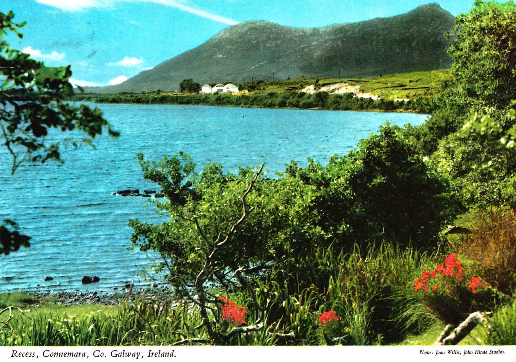
This is one of the choicest beauty spots of Connemara, situated amid beautiful lake and mountain scenery. Glendalough Lake is on one side with Derryclare Lough on the other, north of which Lough Inagh stretches along the great valley of Glen Inagh, separating the Twelve Bens from the Manmturk Mountains. Recess is the home of the world-famous Connemara Green Marble Industry and a full display of these high-quality marble products can be seen here.
Having never-ever in my life heard of that rock, I’ve had a look: Connemara Marble (Wikipedia), and the below is from Patrick N. Wyse Jackson, et al., “Connemara Marble, Co. Galway, Ireland: a Global Heritage Stone Resource proposal”, Geological Society, London, Special Publications, 486 (2019), 251-68 (references omitted):
The Connemara stone first became popular in the early 1800s and, over time, quarries were opened in at least five adjacent districts in Co. Galway in the west of Ireland between the coastal town of Clifden and Galway city to the east. Adopted widely as a decorative stone by Victorian architects, it was employed for columns and wall and door-panels in ecclesiastical buildings and in large country residences and public buildings (see lists below), particularly in Ireland and Britain. Aside from such utilization, the stone was also popular for altars, chimneypieces, table tops, tazzas, church memorials and as plinths for marble busts. Connemara Marble was a decorative stone of choice for many stone workers who carried out their trade in various marble works and studios in Dublin, Cork, Killaloe in Ireland and also in London. Initial markets for the stone were Ireland and the UK, but in the 1890s it underwent a significant revival in the USA.
The stone has been adopted by both native Irish and returning tourists as a symbol of Ireland. During the First World War Irish soldiers serving in France wore pendants of Connemara Marble shaped into four-leafed shamrocks, no doubt as good luck charms. Following fluctuations in extraction in the early to mid-twentieth century due in part to the unsuitability for cladding exterior walls, quarrying recommenced in some quarries in the last 30 years with some production being for use as flooring, but most stone being worked into tourist souvenirs, small decorative pieces and even as small cubes that can be chilled to keep Irish whiskey cool.
I suppose these work as advertised also with non-Irish whiskey (although, if I had to choose, that other stuff should be single-malt Scottish whiskey).
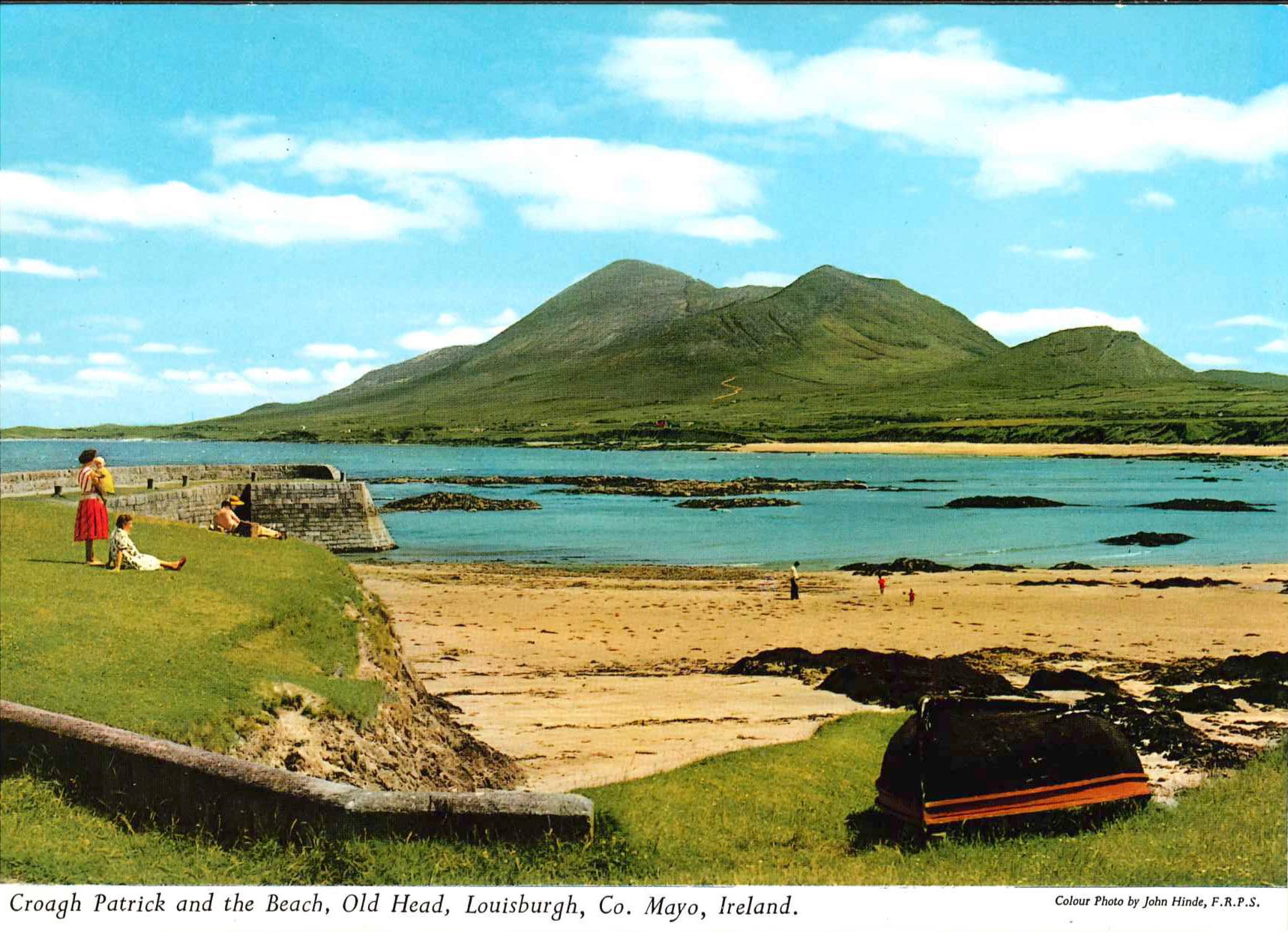
Croagh Patrick, rising 2,510 feet above the shore of island-studded Clew Bay, is one of the most conspicuous features of the landscape of Western Ireland. This is Ireland’s Holy Mountain where St. Patrick, the national apostle, in the year 441, spent the forty days of Lent. Each year on the last Sunday of July, a great national pilgrimage to the mountain is held, and thousands of people make the ascent.
This is, of course, all very intriguing, so I went and had a few more looks around the internet: here is Croagh Patrick’s Wikipedia entry, here is the dedicated entry to the pilgrimage on aptly-called “Reek Sunday”.
For further information, I also visited the dedicated entry on the “Young Irish” website:
The mountain is significant in Irish history and is considered a place of worship predating the arrival of Christianity in Ireland. It was believed Irish druids celebrated Lughnasadh by climbing to the summit of Croagh Patrick, a common practice during the August festival.
In the 5th century, St Patrick climbed to the summit of Croagh Patrick and completed a forty-day Lenten ritual of fasting and penance. An archaeological excavation performed during the ’90s discovered the remains of a small chapel dating to the time of St Patrick.
The pilgrimage today
The last Sunday in July is called Reek Sunday and its when the pilgrimage starts. It is estimated that between 30,000–40,000 make the pilgrimage each year, most of them on barefoot. From children to elders, the pilgrimage is considered an important event to complete.
Safety concerns are constantly considered due to the erosion of the mountain and in some years bad weather. In 2015 bad weather covered the mountain and due to the high risks, the pilgrimage was canceled. Emergency services, including the Irish Coastguard, are on constant standby when the pilgrimage takes place.
A Few Concluding Lines (and Bonus Postcards)
I’ll throw in one more comment here—I’m hardly surprised to find this postcard in the collection, which my grand-aunt sent to her co-worker of decades and friend. Many of these Irish postcards appear to have been bought and sent by my grand-aunt to relatives in Austria, incl. to my grandparents my parents, and my aunt, and the ones that I haven’t posted here include Kylemore Abbey, a reproduction of an engraving of St. Kevin’s in Glendalough, a few of the renowned 9th-century Book of Kells, an illuminated manuscript of the Gospels that can be visited in Dublin (but it’s an “experience” now).
Given the strong faith of my grandfather, I find this hardly surprising, but it’s also an illustration of how travelling and tourism has changed: today, it seems, many a tourist simply goes someplace “to have a good time”, eat out, and conduct a pub crawl (which, truth be told, is something to be done in Ireland).
Back in the 1970s, though, it would seem that trekkin’ across the Emerald Isle to take in the natural beauty and visit its cultural riches, would be done by a choice few, and my fear is that this kind of travelling habit is done by ever fewer people nowadays. Yes, this is a kind of lament, especially given the extraordinary architectural, cultural, and spiritual richness found literally throughout the European countryside.
The most striking of these features are certainly the many churches, chapels, and other places of worship, closely followed by the “other” remnants of Christian Europe’s core feature: city walls, castles and palaces, and other defensive structures that dot the countryside and, today a least, have lost their original functions, if not their attractiveness to—at least—children.
I suppose to nurture an interest at the marvels of a bygone era, it is very much advisable to take your children to every castle, church, and museum around to foster their curiosity.
And before this “lament” gets out of hands, here’s two “bonus postcards” someone appears to have picked up just before boarding the taxi or bus that brought them back to Dublin International Airport: the first one includes a fair share of castles and churches, as well as Ireland’s lovely scenery:

Ireland, an island, is the most westerly country in Europe and covers an area of 32,524 sq. miles. Its greatest length is 302 miles and its greatest width is 189 miles and no part is more than 70 miles from the sea [a feature Ireland shares with Britain, by the way]. The country is divided into four historic provinces, Ulster, Munster, Leinster, and Connacht. Ireland’s fascination is legendary. The unique beauty of its landscape and its rich historic literary and artistic associations have long made it a favourite resort of tourists.
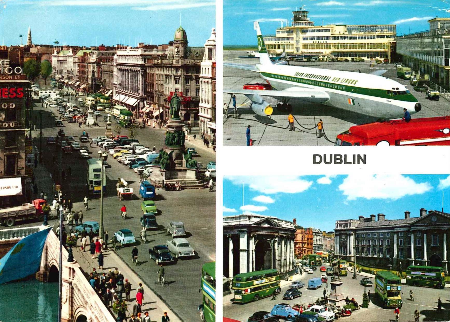
Yet, as beautiful as this trip was, it’s now time for us to make our way through Dublin once more, jump on a plane, and continue our armchair travels.
Godspeed to us all, dear readers, and off we are to distant lands.
Have you ever watched the movie Waking Ned Devine? Gorgeous Irish scenery
I've only had a weekend in Dublin and did the touristy things, but I'd love to go back and spend time meandering the isle.